Almost half a month is behind, and it means another Wialon Hosting update is here, steaming hot and craving your attention. Today you'll learn how to prevent accidental battery discharge of a GPS tracker, calculate the distance from a unit to a geofence, and add geofence description to notifications. Let's start!
How to track the location accurately?
We supported MGRS, a new source of address data in Gurtam Maps.
What is it? To get an idea of MGRS, recall what3words service. It divides the map into squares and describes each one with three words. Everything is a bit more complicated in MGRS: the land surface is presented as a net. Each element of this net has its own code that has from 2 to 14 symbols. The better the GPS accuracy, the more symbols there are in the code.
The service is available by request. You can activate this service in “User properties”. After that, you can use MGRS net in Gurtam Maps and MGRS addressing data in the monitoring panel, reports, and “Address” tool – MGRS code is always displayed next to address info/geofences and coordinates.
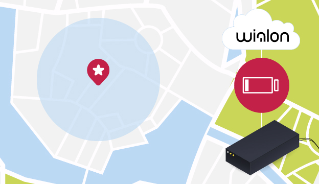
How to charge the tracker on time?
Battery level indication is a long-awaited enhancement. A wireless tracker can run down when it’s impossible to recharge it: the car was stolen, the container is in the open sea or the device works at a remote location.
To avoid this situation, we added a new column to your monitoring panel showing the battery power of all selected trackers.
Top things you need to know about it:
- Battery level is displayed based on custom sensor values;
- You can change the “Battery level” column visibility in the monitoring panel settings, you can select the needed custom sensor there as well;
- Instead of a standard square that changes its color depending on the sensor values, you see one of four special icons for different battery power intervals: 0-25%, 25-50%, 50-75%, 75-100%;
- The icon tooltip shows the exact battery percentage.
Now you’re always sure that devices won’t run down when you need them most. You can miss the low battery notification, but the column in the monitoring panel is something that can hardly be missed.
How to know the unit-geofence distance?
If you have ever traveled with kids, you remember their endless “Are we coming soon?”. The dispatcher or the customer feel the same when waiting for costly cargo.
To reduce this impatience we added “Distance from unit to geofence” option. It replaces the exact address with the distance left to the specified geofence. This option is applied where the address information was previously displayed:
- Reports – now you know how the distance to the geofence was changing with time;
- Additional information and tooltip – you track the distance in real time;
- “Address” tool– if there are any geofences within the radius of the specified address, the system will make a list containing their names and distances to this address.
The user specifies the geofence search radius that can’t exceed 100 miles and selects the needed geofence (harbor, warehouse, airport).
What for?
- The rented car is moving towards the state border. There are 500 meters left to the “Border crossing point” geofence. It’s about time to remind the driver he is on thin ice.
- The vessel is moving towards the harbor and its current location can’t be tracked by addresses. Positioning data is also not the alternative. Just activate the “Distance from unit to geofence” option and track the unit in real time.
How to describe a geofence through a notification?
Super simple! Use the new %ZONE_DESC% tag to add the geofence description to the notification text. Thus, the driver will learn what awaits him at the specified road section. Let’s compare:
- “SCANIA unit enters the “Dangerous” geofence.”
- “SCANIA unit enters the “Dangerous” geofence. This road section is notable for migrating deer, slippery surface, and an amazing mountain view. Be aware of these things.”
Through this description, you draw the driver’s attention to what is really important.
Two-factor authentication enhancement: how to get a verification code without SMS?
In January, we added the option of two-factor authentication: the user enters his password and the verification code received by SMS or e-mail. But sometimes SMS can’t be delivered due to some side reasons. To avoid this, we added the option of getting the verification code at the e-mail if you failed to get it via SMS:
- After entering the password click “Resend the code” link;
- Select “E-mail” in the dialogue;
- Check your e-mail and enter the code on the authorization page.
How not to miss the account blocking notification?
After you received the first account blocking notification, you still have time to fix the problem. For you not to miss the payment deadline we added the option “Notify about account blocking by e-mail”. Upon its activation, you start getting these notifications daily five days prior to blocking.
You can activate the option and specify your e-mail in user properties or user settings.
IMPORTANT! To use the option, activate “E-mail notifications” service in CMS manager.
That is all so far. But you know of course that we work day and night to make the system better for you. If you have any ideas, share them with us at our forum. See you next month!


.png)
.png)

.png)