About the project
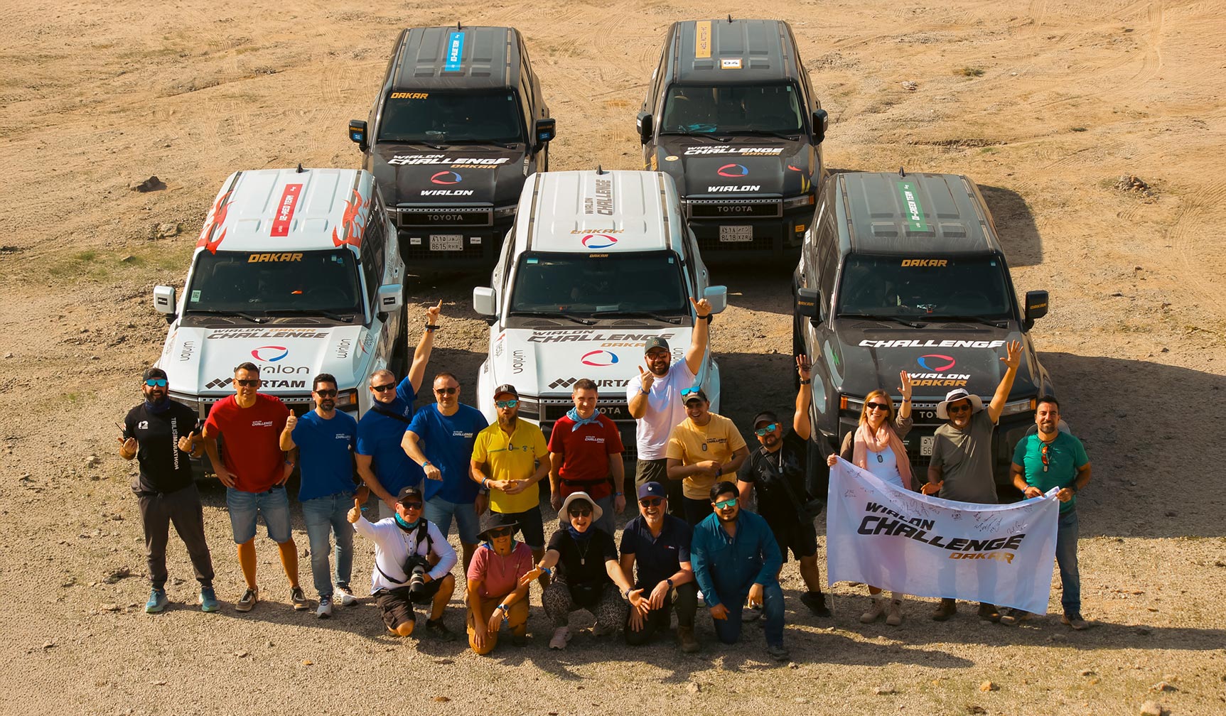
The Wialon Challenge Dakar 2026 was a community event that brought Wialon partners to the Saudi Arabian desert for a 5-day competition held alongside the Dakar Rally. 16 participants from 14 countries were split into teams — Blue, Red, Green, and Yellow — each with 3 Wialon partners and 1 Gurtam team member on board.
Over the course of the challenge, teams raced across the dunes in Toyota Land Cruiser Prados, completing 68 missions that tested their navigation skills, endurance, creativity, and quick thinking. By the end of the challenge, the team with the highest total score took the win.
Wialon served as the technical backbone of the entire competition — monitoring vehicles, ensuring safety, and automatically validating mission results in real time.
The Wialon Challenge Dakar participants
Beyond the competition, Wialon also monitored the journey of the Gurtam Toyota Gazoo Racing Team Baltics to the Dakar Rally. The support truck and race car (a Toyota Hilux) were tracked across a 6,817 km route from Vilnius, Lithuania, to the starting line in Saudi Arabia.
Challenge
Organizing a multi-day competition in the Saudi Arabian desert posed challenges far beyond typical fleet management scenarios.
The Wialon team needed to ensure:
- Real-time monitoring of multiple vehicles in remote areas where GSM coverage is not a guarantee
- Reliable navigation and checkpoint control in an environment without addresses or physical landmarks
- Automated and objective validation of missions and scoring in real time
Read on to find out how the Wialon Technical Care team repurposed core fleet management functionality, such as geofencing, notifications, and reports, to run a real-time competition across the Saudi Arabian desert.
Solution
Phase 1 — Tracking the road to Dakar
Hardware components
To follow the support truck and a race car inside it, from Lithuania to Saudi Arabia, the team went with a combo:
-
Topflytech TLW2-12B — for GSM tracking on land. Its large internal battery proved especially useful when the truck stayed parked with the ignition off for long stretches.
-
Garmin inReach Mini 2 — for satellite tracking once the truck was loaded onto a vessel and headed across the Mediterranean.
Software
-
Wialon. Live location was shared via Locator — a tool that generates a shareable link to a vehicle's real-time position, with no account or login required.
"Near the Suez Canal, the track suddenly turned into a strange spiral. It wasn't a glitch — the ship was literally circling, waiting for its turn to enter the strait." — Artem Filimonchyk, Head of Technical Care L2 at Wialon
Phase 2 — The Wialon Dakar Challenge
Hardware components
5 Toyota Land Cruiser Prado vehicles driven by 4 partner teams and the organizing crew were equipped with two GSM trackers:
-
Teltonika FMC800 (OBD tracker)
-
Teltonika FTC880 (wired)
Connectivity was provided by Onomondo, which supplied SIM cards with international coverage.
Each team also carried a satellite device — a Garmin inReach Mini 2 — for areas without GSM coverage in the desert.
And installation? That became the first mission for our Wialon Dakar Challenge participants.
Software
-
Wialon. The account structure mirrored a standard fleet management setup with a competitive twist. A top-level “mission control” account gave the Technical Care team full visibility across all vehicles. Each of the 4 partner teams — Blue, Red, Green, and Yellow — operated within its own account, like a typical client project. The White (organizing) team had an account with extended access rights to oversee the competition.
-
WiaTag: A mobile app used by participants to turn smartphones into active trackers for "on-foot" missions.
How it worked
The challenge unfolded over 5 days, with missions ranging from feeding camels to rubber duck hunting. Some were completed behind the wheel, others on foot — testing navigation, quick thinking, creativity, and teamwork in different ways.
Many missions relied on Wialon functionality. But they weren’t built to showcase specific features. Instead, the team came up with challenges first — then found creative ways to use Wialon to make them work, just as it happens in real-world business.
Reports and Jobs: Automated scoring
The winners in several missions were determined entirely based on Wialon reports. The Road Warriors award went to the team with the highest daily mileage; the Efficient Navigators, to the team that drove the least.
At the end of each day, Wialon's Jobs feature automated the scoring process: the system generated the required reports and emailed them directly to the organizing team — eliminating manual calculation and ensuring results were always accurate and available within seconds.
Tracks and WiaTag: Drawing in the desert
The GPS Art mission challenged teams to draw a “W” on the map using their vehicle's track in under 10 minutes. The result depended not only on driving precision, but also on how the tracker was configured: more frequent data transmission produced smoother, more accurate lines.
The Red team used WiaTag — Wialon's mobile app that turns a smartphone into a tracker.
Geofencing: Replacing addresses in the desert
Since physical addresses do not exist in the desert, geofences became the primary way to define key locations. Starts, finishes, and checkpoints were created as geofences in Wialon and paired with automated notifications.
-
In the Desert Picnic mission, teams had to enter a geofence as close to 13:00:00 as possible. The system automatically identified the winner the moment their vehicle crossed the boundary.
-
In the SVR Chase mission — inspired by real-world stolen vehicle recovery scenarios — one car had a 5-minute head start while the other had 20 minutes to track it in Wialon, catch up, and read the secret code on its rear window — within a designated "Game Drive" geofence.
-
In the Dakar Navigation mission, teams navigated with a paper map. Each checkpoint was a geofence in Wialon, providing automated proof of every team's visit.
Checkpoints weren't always easy to find.
Additional missions determined by geofence logic included: Prologue Pole Position (the first vehicle to enter the prologue start area geofence wins), Desert Pitstop Arrival (entry timing decides the score), and The Final Sprint to Jeddah (first to cross the digital finish line).
Notifications: Keeping teams informed across devices
Automated notifications were delivered via Telegram and Garmin inReach. However, adding context to Garmin alerts required bridging data between different devices — monitoring events in Wialon and triggering commands on Garmin — which isn’t supported by standard configuration, so the team extended Wialon’s capabilities using its API.
When standard configurations weren’t enough to deliver contextual alerts (who entered a geofence, when, and where) to a specific Garmin device, the team extended Wialon's capabilities using its API.
"The teams were already in the desert, so I had to bridge the gap using the Wialon API — fetching notification events, mapping them to the relevant Garmin devices, and triggering custom commands. With no time for manual coding, I turned to AI. I provided the logic and API flags, and Gemini generated a Python script in minutes." — Pavel Chabatarou, Technical Care Engineer at Wialon
This is just a glimpse of the missions our participants faced. Want to see how the Wialon Challenge Dakar 2026 unfolded day by day?
Results
The Wialon Challenge Dakar 2026 demonstrated that Wialon’s versatility allows it to function far beyond standard fleet management, even in extreme conditions.
"I fell in love with Wialon all over again. It was impressive to see how long-standing features could be combined to support an entire desert expedition. We didn't need a specialized “competition” module; we relied on core functionality and experience to solve every challenge the desert threw at us."
— Artem Filimonchyk, Head of Technical Care L2 at Wialon
Wialon monitored the full journey of the Gurtam Toyota Gazoo Racing Team's convoy from Vilnius to Saudi Arabia, including stretches at sea.
For 4 Wialon Challenge Dakar teams, the system tracked a combined 7,665+ km and recorded top speeds of up to 172 km/h.
Despite limited connectivity and harsh desert conditions, the solution delivered reliable real-time performance — ensuring continuous visibility and uninterrupted mission control during the challenge.
Wialon’s core tools, such as geofencing, automated notifications, and reports, supported a significant share of the competition's missions. The system’s flexibility allowed the team to adapt it to unpredictable scenarios in real time.
Wialon's Jobs feature automated daily report generation and delivery, ensuring fair, instant results across all data-driven missions.
Wialon's open API enabled the team to build custom logic — a cross-device notification routing — in minutes, using AI-assisted scripting.